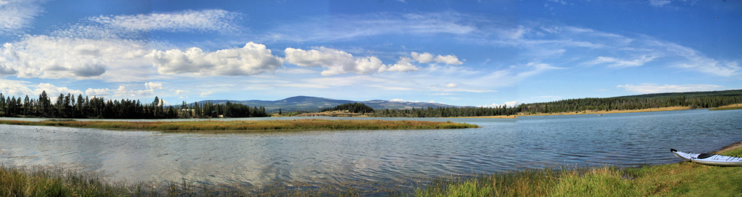
When the weather gets hot, we often go to the high country to find shade, to be next to a lake, and to enjoy moderate in the hills trails. In this last outing, we brought our kayaks and paddled 2 loops around the lake then hiked one loop around the lake.
We find the water in Stake Lake to be remarkably clear as follow the shoreline around for each 3.3 km loop.
After one loop, we swing the boat around to do the second loop in the opposite direction, On the western shore there is an osprey nest so we paddle in close to see if there is any activity at the top of the broken tree,
Stake Lake is a relatively quiet lake in the summer and we may see another paddler, but fishermen are not often encountered.
After paddling 4.6 km, we stowed the boat and hiked around the lake. The main loop around the lake is 2.6 km, but there are many route options.
Although there is no striking scenery along the Stake Lake Trails (except for the basalt bluffs on McConnell Hill), there are birds, insects, flowers, marshes, wildlife, trees, lichens, fungi, and rocks to observe, especially if we hike quietly. Wild strawberry season is approaching and the flowers lined the sides of the trails.
Butterflies and other pollinators are visiting the flowering plants of the area.
Bees are attracted to vetch and peavine in the open areas near the trails.
Caterpillars were cater-piling in the trees.
Various birds flitted from tree to tree along the loop. Blackbirds and a kingfisher were on the shoreline. A cedar waxwing flew from branch to branch in the open forest.
There were remarkably few mosquitoes, partly because there were lots of dragonflies and damselflies to prey on them.
Red columbine was displayed in forest glades or at the edges of trails.
Indian paintbrush was growing on dry open slopes and at the sides of trails.
Common blue butterflies were pollinating the strawberries.
We were tempted to go for another loop on the Stake Lake trails but we ended up with just three loops, but we will be back more times this summer for additional loops on the lake or on the trails.
Bonaparte Plateau is a high forested area north of Kamloops. Access is by backroads. Jamieson creek Forest Service Road is the best road to use from Kamloops. All hiking and paddling in this remote area requires a good sense of navigation and preparedness for the backcountry. The best hike is to Skoatl Point. The other hiking trails follow deactivated roads, tracks, and seldom-visited fishing/hunting tracks, usually with lots of windfall. There are many lakes on the plateau, but only a few with easy vehicle access.
Some of the trails have been there for decades, but pine beetle kill, spruce bud worm, and lack of maintenance has made them impassable. The routes in from Tranquille Lake, the Deadman’s Road, the Wentworth Road, and others can be done, but a 4×4 and preparation for removing deadfall, flat tires, low fuel, and navigating the backroad is advised.
The Google Map here has zoom, pan, sharing, full-screen, and embedded pictures, links, and more information:
Some Images of Hikes and Paddles on the Bonaparte Plateau:
At the upper end of the Lac du Bois Grasslands at 983m (3225 feet) elevation the area turns to forests, ponds, lakes, marshes, backroads, hills, and a few trails. To the south of McQueen Lake are the Nature Conservancy of Canada Lac du Bois Conservancy lands, accessible on foot to hikers and snowshoers. To the north are forested hills, a series of cutblocks in the hills between 1000 and 1400m elevation). To the east is the upper end of the Lac du Bois Grasslands Protected Area. Rough backroads can be hiked or biked to the McQueen Creek grasslands. The Community Grasslands Trail bears east for 14 km to Deep Lake. Opax Mountain is on the west side. Some tracks lead up its slopes, but it is remote and not an easy area to navigate. There are several articles on this site on hiking Opax Mountain.
TheMcQueen Lake Environmental Education Center is run by School District #73. Visitors are asked to not use the trails when students are on-site. There are alternate routes to the lakes, ponds, and meadows (see the map below). Just 4.5 km past McQueen Lake is the Isobel Lake Recreation Site with a number of opportunities for outdoor recreation. Pass Lake Recreation Site is 2.5 km west of McQueen Lake.
In this interactive Google map, information, links, and images are provided. Use the controls to see it as a full screen map, to zoom in or out, and to pan to different areas.
A few Images of the McQueen Lake area are provided here:
From Sun Peaks Village to McGillivray Lake is a 6 km route on a gravel road. Along the way and nearby are snowmobile access points, backroads for mountain biking, lakes for paddling, and trails for hiking, cross country skiing and snowshoeing. The Google Map below has information, photos, and links on these recreational opportunities. The map has zoom controls, pan capacity, sharing functions, full screen view, and embedded photos.
The route is a good gravel road. It is possible to continue south to the Amphitheatre Lake turn and complete a loop route back to Whitecroft on the Eileen Lake Road. The road also descends from the Cahilty Plateau down to Neskonlith Lake (closed in winter).
a bald eagle at Morrisey Lake
We will return to paddle, snowshoe, cross country ski, and hike the McGillivray Lake area.
The Deadman Valley runs north for over 50km from the Trans-Canada Highway, a scenic drive, but also a good route to explore lakes, falls, hoodoos, and backcountry routes. Each time we make the whole-day trip, we pick new points of interest for more exploration. Last year, it was Deadman Falls, Sherwood hoodoos, and Snohoosh Lake (Deadmans Tour). This year it was Deadman Falls, Deadman Gorge, and Deadman Lake. On our next trip, we will paddle Hihium Lake and hike up to Split Rock.
We drove up the length of the valley right to the trailhead to Deadman Falls and walked to the brink of the canyon. The river was rushing down to the edge of the basalt lava cliffs where it plunged 200 feet to the bottom of the gorge. The sources of the Deadman River are the lakes and uplands meadows of the 4000 foot Kukwaus Plateau to the northeast. The viewpoint on the north side of the gorge is at the top of sheer cliffs, making it difficult to get the full falls into a photo. It is a spot to show lots of caution.
We followed the rim downstream to a side valley, then scrambled down a very steep slope to the bottom of the gorge at edge of the river. There was clearly no way to work our way up the gorge to the base of the falls. It was just a series of cascades surrounded by cliffs on both sides. We scrambled back up the way we came.
On our way back down the Deadman Valley we stopped at the Deadman Lake Recreation Site for lunch before launching our kayaks for a paddle around the lake.
This lake is surrounded by forest and a complete circuit is only 3.2 km. A mother loon had a hatchling on her back on the north end of the lake. There are a couple of summer homes on the lake, but there was no one around on a weekday in May.
Lava flow cliffs and sculpted erosion slopes can be viewed along the 50km length of the valley, all requiring further exploration, another reason to return to the Deadman River Valley.
Camping at Juniper Beach Provincial Park has both good and not-so-good features. On the less-desirable side, two railroad lines flank the spot and trains run throughout the night. The site has a few trees but for the most part is open and the campsites are side-by-side facing the river. There is power and water for hard-sided units now, along with showers, waste-water disposal, outhouses, picnic tables, a day use area and a beach.
On the good side, the river is a beautiful spot. Gravel bars with some sandy sections front the fast-flowing river. When the river drops, it leaves a pond, perfect for the little ones.
I launched my boat and tried to paddle up the river. The river runs very fast through this part of the canyon and I could only get up the first set of rapids, but could not get through the next set.
Turning back downstream are a series of claybank slopes and hoodoos.
Below the river is another set of Class 2 rapids. I wasn’t sure if could get back up them so I turned around and had to paddle hard upstream to get up to the campsite. Although it was fun to paddle through the fast water, the choices here are limited. We have paddled downstream from Savona to Juniper Beach before and it is a fun route with a number of Class 2 rapids along the 20 km route. Launching from Juniper Beach, though, does not offer much to a paddler.
We walked along the gravel bars up and down the river. The barren hills above show the semi-arid south-facing slopes of the Cache Creek – Arrowstone Hills.
From Juniper Beach are a number of interesting tours – Walhachin, Deadman’s Valley, and Back Valley. We chose to drive up the Battle Creek FSR to the Back Valley Road, then turned right to go east toward Deadman’s Valley in a 52.6km loop.
[map style=”width: auto; height:400px; margin:20px 0px 20px 0px; border: 1px solid black;” gpx=”https://kamloopstrails.net/wp-content/uploads/Back Valley Loop.gpx” elevation=”no” download=”no”]
Along the route we passed some lava cliffs in the Battle Creek Gorge, then Stinking Lake and Cultus Lake. As we descended into the Deadman’s Valley, the eroded cliffs and hoodoos rising above the river are another point of interest.A more ambitious choice from the Back Valley Road would be to climb into the Arrowstone Hills, but there are no established trails. We plan to find some routes, but this is a big, remote area that will take some time to explore.
Apart from the railroad and the side-by-side camping, the area fronting the river is a nice spot for peaceful camping and walking. The alpenglow and rising moon signaled the end of each day while camping at Juniper Beach.
Every year a paddle across Kamloops Lake to Painted Bluffs is planned, but I vary the hike in the hills. To avoid the strong winds that can blow down Kamloops Lake in summer, I watch the weather forecast carefully. This year the launch point was in Savona and a double loop was chosen, one on the lake, and one in the hills.
The 2 km crossing of Kamloops Lake is best done in calm conditions in a seaworthy kayak. The south-facing barren hills across the lake rise above the north shore of the lake.
Passing Copper creek, the edge of Painted Bluffs Provincial Park comes into view.
By July there is a good beach landing spot in the bay past the train tunnel.
From the beach, there is no trail up the shoreline and over the tracks. There is some poison ivy above the waterline, but also a number of wildflowers there and above in the hills.
primrose
white clematis
blazing star
poison ivy
The shapes, colors, and alien landscapes of Painted Bluffs comes into view right after crossing the tracks.
The park area is surrounded by rocky grass-covered hills overlooking Kamloops Lake. A loop through the bluffs and then up to the tops of the hills was part scramble and part hike. The view east extends past Six Mile Point and Peregrine Bluffs.
Last year I launched from Tobiano, following the shoreline west from Peregrine Bluffs.
It is about 13.5 km to paddle from the east end of Savona to Painted Bluffs and back. The lake was calm on the return paddle, about 1.25 hours each way.
This is an annual event within the summer schedule, one of the best paddling routes of our area.
The drive to Bella Coola and back has long been a call-to-explore and a week was set aside into the calendar for the tour. It is 740 km each way so I got an early start on a Monday morning. The road is paved all the way to Anaheim Lake so I proceeded along the route, stopping for gas as needed. The gravel section started just before Tweedsmuir Provincial Park and there were no vehicles along the upper section of the park. The weather was fine and I stopped at some trailheads in the park to scout out future hikes. Wide views were impressive at the top of Heckman Pass and I proceeded carefully down the Big Hill. I was happy the road was dry and I wasn’t pulling a trailer on this daunting 16 km section of road.
The Bella Coolla Valley was impressive with steep-sided mountains all around, glaciers and snowfields above, and waterfalls and creeks entering the valley into the Atnarko and Bella Coola Rivers. All of the campgrounds in Tweedsmuir were still closed and there were no vehicles at all in the upper valley. This is a coastal cedar-hemlock wet coastal zone forest with fast-flowing streams and dense green forest.
In the middle part of the valley, Hagensborg is a small community with Norwegian immigrant history. There were some services, regional parks, and a nice ambience to the area. Coming into Bella Coola was a bit surprising. The community is in a beautiful setting, but seemed a bit run-down. I drove past the town out to the Government dock where the ferry used to land, then beyond to a small regional park for a view out the North Bentick Arm.
I drove through the town and looked for a gas station. The one gas station was closed and though I wanted to stay in Bella Coola, I had to drive back up the valley where I ended up paying $3.84 a litre! A big disincentive to staying in town. I decided to looked for a camping spot near the western edge of Tweedsmuir Park. I spotted this this old homestead along the way.
I had noted some possible camping spots on the western side of Tweedsmuir Park and I settled on a spot by Burnt Bridge Creek, very near the end of the Alexander Mackenzie Heritage Trail.
The weather was mostly clear on day one. The moon was shining over the Coast Range in the middle of the night..
An early morning start and choices to make – paddle in the Bentick Arm or on a lake up in the Chilcotin? The weather was changing and I didn’t want to drive the Big Hill in the rain, so I made the decision to head east. The Big Hill is very steep, unpaved, and has drop-offs at the shoulder all the way to the valley floor 4000 feet below. I carefully drove the 16km section to the top at Heckman Pass. At the top is a viewpoint back across the Coast Range above the Bella Coola Valley.
The upper part of Tweedsmuir Provincial Park has high (5000 feet) wet meadows and small lakes.
The plan for the day was to hike the first part of the Rainbow Range Trail in the morning.
Just before the trailhead, I spotted two silver-backed grizzly bears stumping along the meadows not far from where I had planned to hike. There were no other vehicles around and I was hiking alone. So, I drove on.
It started to rain west of Anaheim Lake. I chose to drive east to attempt to outrun the weather. At Nimpo Lake, the weather cleared a bit so I found a boat launch and paddled for 2 hours on this peaceful lake.
At the end of this pleasant paddle, the weather started to deteriorate. The plan was to turn down to Tatloyoko Lake to hike, paddle, and camp for a day or two. When I reached the turn-off, the rains had resumed, but more heavily now so rather than tent in the rain, I continued east. The weather really came in after that.
My plan to paddle Charlotte Lake, Tatla Lake, and Tatloyoko Lake and to hike around Tatloyoko was rained out. I continued east. At Riske Creek I turned down toward Farwell Canyon. The roads were muddy by this time and I passed quite a few loaded logging trucks. I stopped at the Sheep Junction Park trailhead and went for a walk along the track, but the rain discouraged any further exploration. This will be a return bike/hike.
Farwell Canyon was in a grey weather zone, but it was nice to see the hoodoos above the Chilco River.
In the end, I drove all the way home. The planned 5 day trip to Bella Coola and the Chilcotin took only 2 days. It rained for the next day and a half after that. The road trip was quick, but it was fun to see all the villages, Reserves, ranches, rivers, lakes, and mountains along the way. This became a “scouting trip” for a return (summer) trip to hike and paddle sometime in the future.
It would be rare to meet someone at Painted Bluffs. It is a remote and quiet spot on the north side of Kamloops Lake. For those who do visit the site, most stay on the lower slopes, but some of the upper gullies and ridges have some surprises for explorers. On this last paddle and hike, I was able to find a gully that took me all the way to the top and then used two more gullies to come down into a different area. New views and some finds awaited me.
Blazing star
Bighorn sheep skull
An old mine opening
Boulders on the wash
The descent came down a gully into another world, a primeval and strange landscape, a place to quietly focus one’s sense of wonder.
High on the ridges in a barren, infertile soil infused with iron, copper, and cinnabar, a few scrubby plants survive and some blazing stars can be found in unlikely spots.
As winter approaches, we reflect on the seasons now past and a few special places blaze in our memories. Canyonlands, Zion, Azure Lake, and Painted Bluffs burn bright in our connections to the outdoors.
The 500th article was published to this site. At the same time, about 920 000 separate visits were logged. Then the database was inadvertently wrecked and the site went down for two days. I wasn't sure it could be recovered, but I got some technical help and once I could get into the backend, I have been doing some additional repairs.
The kamloopstrails.net site was started as my first website and it evolved over time. The only way to find articles is to Search using the Search Bar above. The main feature is the current post, but it is not easy to find information if you are looking for a specific route. I have been thinking about reorganizing the site, but I have chosen to add another site instead and provide links between the two. See www.kamloopstrails.com for a preview.
We try to visit Painted Bluffs every year. It can be done by driving the Sabiston Creek Road and then down to Copper Creek. but this is a long and awkward route. Our preference is to paddle over from Savona, a 6.5 km route (each way) with a 1.5 km lake crossing.
There is a beach below the park suitable for landing a boat. Be careful of poison ivy in the area behind the logs. Follow the dry creek drainage into the foot of the hills, then pick your own route to explore the multi-hued cliffs, stained with copper, cinnabar, and iron. Each time we explore the area, we pick a different route. The combination of perspectives and light conditions makes each visit a new experience.
From the east side, we found new views down to the lake.
Each perspective brings new detail.
One of the few places the blazing-star can be seen is at Painted Bluffs in June and July. It was in bloom on barren sandy hillsides.
After lunch on the beach, the winds had picked up. This is always a risk in paddling Kamloops Lake. Crossing Kamloops Lake is best done in ocean-kayaks (16'+). We angled off into the wind, a 2.5 km challenging crossing, but once across, we followed the shoreline west with the wind at our backs.
Images of Painted Bluffs stay with us for the months to follow.
Johnson Lake sits high in the hills above Adams Lake. The best road up to the 3800 foot lake is from the Agate Bay Road. The road is wide and well-graded. The other route is from Adams Lake, either from Brennan Creek or from the 28.5km mark. I followed the latter route which climbed through a series of switchbacks with some nice views down Adams Lake. Although the area has been logged, there were no recent cuts and cedar forests covered the upper valleys.
At Johnson Lake, the road on the south side is a good one, I pulled into the BC Forest Service Campsite at the east end. I launched my kayak and paddled the shoreline loop of the whole lake, an 11km route. The water is crystalline blue and clear to depths. Every inch of the lake bottom can be seen from the shoreline due to the limestone of the area. Shoals provide interesting viewing and some small schools of fish could be seen in blue water over a white shoal. Cedar forests lined the shoreline all the way. There are a few cabins on the north shore, but three-quarters of the lakeshore is forested. The resort sits at the far south west and narrowest end of the lake. The actual resort is out of site between two lakes and only docks can be seen from the water. At the east end of the lake, the camping area sits on a sandy white shoal with the clearest water I have seen in this area. The Johnson Lake Trails were built for horseback riders, but are used by hikers and snowmobilers too. The trails start at the northeast side of the lake. There are 22km of trails to explore. For a map of the trails, go to this link.
On a hot summer day, this highland gem is a recommended destination.
After a number of years visiting Painted Bluffs Provincial Park, we now only visit by boat. The land route is not easy, nor pleasing. After a long drive to Copper Creek, there is no suitable access because of private property, fencelines, and the railway. On the other hand, a boat can launch from Savona (or Tobiano) and go across the lake, following the shoreline up to the beach at the foot of the bluffs. The landing is an easy one on a gravel beach.
A short hike up the slopes and across the railroad tracks is required. There is no discernible trail, but a route follows the dry stream bed up to the bluffs. Sinuous ridges extend from the hill above. The dominant colors are green (copper), red (cinnabar), orange (iron and algae on rocks). Nothing grows on the narrow ridges, nor in the rills between them. The foot of the bluffs is an eerie spot. A visitor can explore the foot of the bluffs easily or climb side hills for a better view.
On our last visits, we have chosen to climb the ridges for different perspectives, following the colored ridges to new viewpoints.
The narrow ridgetops are a scramble suited to good boots and steady balance and the gullies are difficult to traverse, but the diversity of colors, shapes, and materials brings new rewards to explorers willing to climb to the heights of the bluffs.
There are a few rocky ridges intermixed with the eroded bluffs too. A few scrubby plants can be found among the rocks. In the gullies are pieces of calcite, sheets of mica, and variety of interesting rock samples. First Nations people gathered copper nuggets at the bluffs and nearby at Copper Creek. When we travel to the site, we practice no impact exploration, leaving samples where they were found. On a previous trip, we watched bighorn sheep traversing the upper bluffs, but we try to stay on the tops of ridges or in the bottom of stream gullies, not wanting to erode the sides of the ridges. With almost no vegetation on the bluffs, we were surprised to see blazing stars in bloom on a rocky-sandy ridge.
Painted Bluffs retains its other-worldly beauty because it is in a remote spot. Visitors need to respect the heritage values of the site, taking only photos away with them and leaving no trace of their passing.
Painted Bluffs Provincial Park is a very special place, one that we try to visit every year. Our favorite route is to kayak across the lake from Savona. Other routes can be taken too (see this post link). Every time we visit, the light is different and we hike to different perspectives (post link).
A follow-up article will detail the route and opportunities. For now, a preview is offered:
For those who love to kayak, Jedediah Island is a destination for exploration. Most kayakers launch from the Sunshine Coast. Go north of Sechelt to Half Moon Bay for a good access to a short crossing to the Thormandby Islands. The crossing of Malaspina Strait from North Thormandby is 8km of open water and should only be attempted in calm conditions. We returned by this route in rougher conditions and the kayaks plunged out of sight in the troughs between waves. If conditions aren't good, there is lots of paddling around the two Thormandby Islands and into Pirates Cove Provincial Park.
If the crossing can be done to the south end of Texada Island, another crossing is still required. We found Sabine Channel to be good paddling, but it adds another 5km of open water. The route from North Thormandby to Jedediah is about 3 hours of continuous paddling. there are a number of potential landing spots on the island with Home Bay as the first choice for many kayakers. A narrow channel leads into a protected bay with a beach and camping area. At low tide, all of the landings will be on mud flats, awkward for unloading boats. We observed a group that waited several hours for the bay to fill up with water before landing. The campsite has a kiosk, outhouse, sandy beach and a grassy bench for camping.
All of the camping areas of the island are connected by trails. There are 3.5km of official trails and a few routes to viewpoints too. In Home Bay, the former home of a series of owners who eventually sold the island to the province of B.C. for $4 million sits up on a bluff. Behind the home perched on the hill is an orchard and meadows. A herd of feral goats grazed this area every day. Raccoons came down to the bay at low tide each morning.
Each day yachts, cruisers, and motorboats would take overnight anchorage in one of 7 bays or inlets around the island. Jedediah is a long way from the nearest vacation home so everyone seems to understand the need for a quiet stay at the island. The whole island (243 hectares) is a provincial park, and is a choice destination to visit, hike, and explore. But Jedediah is also surrounded by 30 islands for exploration by water, to be featured in another article to follow.
The Copper Island route has been featured in a past post (link). This time, we left Shuswap Lake Park in flood. All of the beaches were under water. Debris flanked the possible entry points. Mosquitoes were breeding in the standing water in low points. We launched nonetheless and to our delight, the ban on speed boats made the 2km crossing more peaceful. We paddled around the north side of the island to the landing spot on the east side. There is usually a small cove with a pebbly beach landing, but high water covered any possibility of a bow landing. We pulled out kayaks alongside some grassy banks and secured the boats. The hike is a 3km loop, climbing to the top of the steep-sided island. Viewpoints are numerous on the south and west sides of the island.
Flowering spirea, ocean spray, Oregon grape, thimble berry, huckleberry, and mock orange decorate the hillsides. Bald eagles and osprey perched on branches overlooking the cliffs. By the time we paddled back to Scotch Creek, more late-riser boaters were up, but we paddled in a chevron formation back to the camping area. Neither the paddle nor the hike is a long route, but the combined route makes a very pleasant half-day trip in fine weather. This was our third trip, and we will return for many more.
 We find the water in Stake Lake to be remarkably clear as follow the shoreline around for each 3.3 km loop.
 After one loop, we swing the boat around to do the second loop in the opposite direction, On the western shore there is an osprey nest so we paddle in close to see if there is any activity at the top of the broken tree,
 Stake Lake is a relatively quiet lake in the summer and we may see another paddler, but fishermen are not often encountered.
 After paddling 4.6 km, we stowed the boat and hiked around the lake. The main loop around the lake is 2.6 km, but there are many route options.
 Although there is no striking scenery along the Stake Lake Trails (except for the basalt bluffs on McConnell Hill), there are birds, insects, flowers, marshes, wildlife, trees, lichens, fungi, and rocks to observe, especially if we hike quietly. Wild strawberry season is approaching and the flowers lined the sides of the trails.
 Butterflies and other pollinators are visiting the flowering plants of the area.
 Bees are attracted to vetch and peavine in the open areas near the trails.
 Caterpillars were cater-piling in the trees.
 Various birds flitted from tree to tree along the loop. Blackbirds and a kingfisher were on the shoreline. A cedar waxwing flew from branch to branch in the open forest.
 There were remarkably few mosquitoes, partly because there were lots of dragonflies and damselflies to prey on them.
 Red columbine was displayed in forest glades or at the edges of trails.
 Indian paintbrush was growing on dry open slopes and at the sides of trails.
 Common blue butterflies were pollinating the strawberries.


