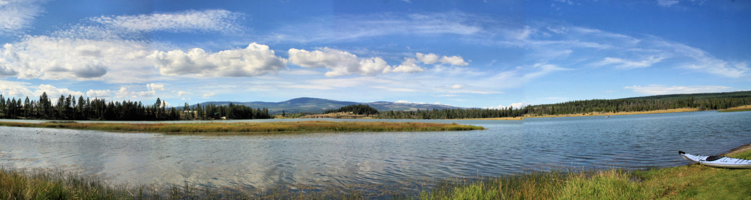
Over the winter I purchased a folding kayak so that I could use a backpack to hike to hard-to-get-to-lakes with a kayak. The first lake for this adventure was Island Lake, a grasslands lake in the middle grasslands of Lac du Bois Protected Area.
With the backpack on, i hiked from the trailhead to the lake on a faint single track and across the grasslands hills to the lakeshore, about 800m.
At the lakeshore I assembled the folding kayak (the Oru Inlet). I paddled around the lakeshore,a 1.2 km route.
The ducks were surprised by my boat, likely the only boat to have ever been on this remote lake. All photos by the author. Click an image for a lightbox view and a caption.
A few moments of the hike and the paddle are captured in this YouTube video:
More backpack and paddle outings are planned for the spring, summer, and fall.
A paddle and hike duathlon was a good choice for a warm summer day. A paddle around Stake Lake was followed by a hike on the Giant Firs Trail. The big trees on the trail are a welcome sight in both summer and winter.
Some moments of both activities are found in this short video:
A favorite combination for summer recreation is to paddle a lake, then hike around it. In August I launched my kayak and paddled the 3 km loop around the lake.
After securing the boat, I hiked the 3.5 km trail around the lake, enjoying some of the larger douglas fir trees by the single-track trail.
There were a few hikers and dog-walkers on the trail and a couple of boats out on the water, but it was a quiet day at McConnell Lake.
This year we have paddled the lake twice, we snowshoed the area twice, and we have hiked the lake loop, each time enjoying the high country forests.
This grove leads to a shortcut trail down to the Dogwood Marshes.
Some video footage was taken during the paddle and the hike, now available on YouTube:
Other paddle-hike locations include Stake Lake, Isobel Lake, Lac le Jeune, Paul Lake, and a number of other lakes that have trails nearby.
On a pleasant spring day I drove up the bumpy road to Pat Lake, sometimes called Six Mile Lake. It is a favorite spring fishing lake, but I stayed close to the shoreline paddling around twice, once in each direction.
There were many birds on the shoreline and on the lake, including blackbirds, loons, ducks (mostly coots), geese, bluebirds, swallows, and crows. There were painted turtles and marmots sunning, frogs croaking, and a variety of active insects.
After paddling I hiked around the lake, enjoying the Six Mile Hills.
Video captures the calls of the birds and the soughing of the wind:
I will be back to do a larger loop through the Six Mile Hills.
To get to Murtle Lake, we have to drive to Blue River, then drive up into the mountains for 23 km. At the trailhead we have to load the kayaks onto carts and portage for 2.5 km. At the boat launch on Murtle Lagoon, we then paddle for 12 to 14 km to camp at a marine campsite. On this trip to Murtle Lake, we camped on Leo Island. On this particular trip, I did a solo paddle and hike to Central Mountain. I paddled 1.5 km to the trailhead at a sign on the shoreline. There wasn’t much of a landing so I hauled my kayak up the rocky shoreline, then put on my hiking boots.
The forested trail was steep and grown-over in some sections. It is not hiked much so the trail is indistinct so some navigation was required.
The hike to the top of the mountain is 7.5 km. Near the top I passed through a subalpine meadow with views down the West Arm of Murtle Lake. Bears frequent the area so I made noise on the way up. The open meadows on top are part of a caribou migration route, but I didn’t spot any.
The alpine area was open with meadows and rock outcrops, and wide views.
From the southern edge of the summit. I could see down to Leo Island below, our marine campsite.
From the summit, I chose to continue east to the edge of the slope break to see if I could see down to the lake.
From a viewpoint the North Arm of Murtle Lake was below, with the Wavy Range above, on the east side.
I continued farther north and came to a viewpoint of the north end of the North Arm of Murtle Lake. The Murtle River drains into the lake from the Cariboo Mountains in Northern Wells Gray Park.
This turned out to be a long day of hiking. The return hike is 15 km, but I added more distance by traversing across the top of the mountain east, then north.
The hike is really only for experienced backcountry hikers who can navigate and be self-sufficient. It is not a hike I will do again, but I am happy to have done it this day. A Google EArth Fly-Over is shared here for an overview of Central Mountain.
On a hot summer morning I chose to drive up to Lodgepole Lake to do some loops – twice around the lake in a kayak, then once around the lake on the Lodgepole Lake Trail. The trailhead starts at the end of the Recreation Site campground and winds around the lake. The loop route is about 2 km.
There is a lot of windfall all around the lake, but it has been cleared by volunteers and the Rec Site contractor.
contThe trail comes out to the Forest Service Road and I walked along the road back to the trailhead.
Three loops amounted to about 4.5 km, a shorter outing, but just right for a day that would be about 46 degrees C.
We hike, bike, cross country ski, snowshoe, and paddle in the Stake Lake Trails system. In summer we sometimes paddle around the lake 1-3 times, then we go for a hike on the trails. On this warm summer day, I paddled twice around the lake in calm conditions.
Each loop is about 2.25 km.
We secured the boat then hiked on the double track trails, but we also went onto a single track snowshoe trail too.
The hike added another 5 km.
Along the way, we stopped to enjoy wildflowers, pollinators, and the forest. Click an image for a caption.
We will be back for another duathlon – paddle then hike over the summer months.
When the weather gets hot an option is to drive to the high country (4000 feet+) and paddle one of the lakes, then go for one of the hikes nearby. On this blue sky hot day, I paddled twice around Stake Lake, then hiked a snowshoe route nearby. It was an early morning start and winds are usually calm until late morning in our area. There was no one else on the lake.
We spot western painted turtles in a number of our area lakes, particularly murky lakes with marshy areas. We were surprised to spot one on the western side of Stake Lake which is a clear-water lake.
Across the Lac le Jeune Road is a series of open marshes and a number of double tracks can be hiked or snowshoed, linked into a loop, although some route-finding is required. The marsh reeds were starting to turn colour in late summer.
Butterflies were out on wildflowers along the route. This skipper was spotted on clover.
A swampy area in the forest was surrounded by rushes and reeds.
There were lots of late-summer flowers, mostly taller varieties, but a few low-growing wildflowers like self-heal (prunella vulgaris) could be spotted with careful observation.
Going into the high country offers some relief from the hot summer sun, especially if combined with an early start and a forested route. Paddling and hiking in the middle of the day in open areas is best left to shoulder seasons.
My plan was to paddle Minnie Lake (and possibly Stoney Lake) on the Pennask Lake Road, then tour through the Douglas Plateau on the way back, but winds picked up and by the time I reached Minnie Lake, there were whitecaps on the larger open lake.
Minnie Lake
I decided to drive through to the Douglas Lake area and evaluate the winds on other lakes (Douglas, Chapperon, Rush, Salmon or possibly Glimpse Lake). I turned off the Pennask Lake Road and headed over the hills to Douglas Lake. The secondary backroad was a bit rougher in spots, but was fine for a truck or any high clearance vehicle.
The whole area is a large and beautiful grassland with open forest on the higher slopes.
An old abandoned homestead stood off the main road where the Douglas Lake Ranchlands give way to the Upper Nicola Douglas Lake Reserve (#3).
Along the Douglas Lake Road I spotted a rocky beach just below so I parked and hauled my kayak down to the shoreline. I paddled the south shoreline in strong winds, avoiding the open lake where more whitecaps were cresting from winds blowing from the southwest.
I decided to follow the road east past Chapperon Lake, Rush Lake, and Salmon Lake, then over the hills and down into the Salmon River Canyon. The winding and sometimes narrow road crosses the Salmon River then not far ahead is another bridge over Weyman Creek. There is a small parking area on the north side and a hard-to-see trail climbs the hill following the creek into a canyon. The trail ends at a spot overlooking Weyman Falls, but I had been there before and this time I scrambled down to a lower viewpoint of the 100 foot falls.
I hiked back out to my truck then finished the tour by going through Westwold to loop back to Kamloops on Highway 97. I didn’t get to paddle Minnie Lake, but I had done that in the previous year (link – Minnie Lake), I did get to do a shorter paddle on Douglas Lake (a first for me), and I got to see Weyman Falls from the low end at full flow. Another good day exploring the hills, waterways, and backroads of the Interior.
I paddled out of Cooney Bay in April and instead of heading out into the bay and then farther out to Kamloops Lake, I chose to paddle upstream into the shallow river channels and explore the delta sand islands. At low water, the river divides into 3 channels near the mouth before entering Kamloops Lake. The main channel is about 2/3 of the way across to the other side. The water moves more quickly there and is deeper. On the north side of the mouth are two channels, the one closest to Cooney Bay and one shallow channel farther over. In between the channels are a number of sand islands. At low water, the islands dry out, some with a few logs or other debris. I paddled up the first channel, past the gravelly beaches and cottonwoods by Tranquille.
I paddled up the first channel and then down the second one, watching for shallow spots since its no fun to ground the boat. I turned the corner at the lake mouth, then went up the main channel, paddling against the current and landed on a sand island.
I explored the island, examining debris and tracks. There were lots of bird tracks (mainly seagulls), but there was also a river otter tracks that started at one end of the island and went across to the other side. I have spotted river otters in this area a few times, especially during freshet.
I paddled over to the next island and explored it too. I tried wading through shallow water between the islets, but the super-saturated silts were like quicksand, with my boots burying deeper with each step.
After exploring 3 islands. I paddled to the south shore then looped back through deeper water in the lake to the launch spot at Cooney Bay. All of these islands will be covered in water by now and will have to wait until mid-fall to dry out again.
We are lucky to have access to this area, but it is rarely explored, except by a few who kayak into the lake.
Painted Bluffs Provincial Park lies on the north side of Kamloops Lake east of Copper Creek. Access by land is difficult, but it can be done from the Copper Creek Road just below the Sabiston Creek Road junction (link). We have been in to Painted Bluffs five times in the last 2 years, with the last time by kayak from Savona. We paddle on Kamloops Lake a few times each year, but we always check for weather conditions before heading out. Typically the lake is calm in the morning and winds arise after 11:00. Strong winds may be difficult for paddlers and they are often at their worst at about noon. A crossing of the lake is about 2 km.
There is an official boat launch on the west end of Savona, but we hand launched from the former Savona Provincial Park area not far from the mill instead. Access to the parking area and the beach below is blocked by large boulders so we parked on the side of Savona Access Road, then hauled our kayaks down to the beach (using rear wheels). The beach is rocky but this is no problem in calm conditions. We launched and then angled northeast to the far shore. The paddle to Painted Bluffs is 6.5 km.
It takes about 1.25 hours in calm conditions to paddle across the lake and up the shoreline past Copper Creek. The whole route over and back is very scenic.
There is a good beach/shore for a kayak landing. We pulled our boats onto the beach and hiked up across the train tracks and into the bluffs. As we approached the ragged ridges and gullies, there was very little vegetation below the cinnabar, iron, and copper infused slopes.
There are no trails, but with some light scrambling we can go over ridges to gullies that can be hiked or we can hike up the narrow eroded ridges.
All exploration is limited by eroded green (copper) red and orange (cinnabar and iron) ridges Over the years we have clambered over all parts of the park.
The outing was on 9/11 and only by serendipityI spotted and took a photo with N11 in it.
Every trip into Painted Bluffs is a bit different because of changing light conditions. Ragged shapes and patterns can be seen, depending on the angle of the view and the light. No matter how many times I hike in Painted Bluffs, my sense of wonder is never diminished.
We paddled back just as the winds came up and we had about 1 km of concentrated paddling with waves coming out of the southeast. We came under the shelter of Six Mile Hill and then paddled west along the south shore of the lake back to Savona.
This is an outing that we try to do every year. The combination of paddling on Kamloops Lake surrounded by its scenic, rugged hills and hiking in Painted Bluffs is a prime Double Feature for our summer.
Tsintsunko Lake Provincial Park is a 333 hectare park on the Bonaparte Plateau at an elevation of 1603 m (5260 feet). The B.C. Parks lands are along the eastern side of the lake and adjacent interconnected wetlands. The area to the west has been extensively logged. Access is on a combination of Forest Service Roads (Jamieson Creek Road > Deadman Road- Beaverhut Road) requiring some navigation to get to the right access area. The lake can’t be seen from the backroads and access is by primitive walk-in trails/tracks only. We had previously hiked on a designated trail to Jolly Lake, then on faint tracks over to Tsintsunko Lake and back by the Beaverhut Road (link to article) so we knew the area enough to want to return to paddle the lake. There are a couple of rough tracks into the lake from the road so we chose to mount our kayaks onto a portage cart and pull them on a 0.75 m route. This was hard work, but we got our boats to the lakeshore for a day of paddling and exploration.
A paddle around the lakeshore is a 6.3 loop. With exploration in each bay, it took about 2 hours.
Englemann spruce, alpine fir, and lodgepole pine surround the lake on the high plateau.
A number of glacial rocks (erratics) stuck up out of the lake’s surface. The largest “shark-tooth” guarded a narrows between islands.
On the west shore is an old fishing cabin, built before the park was created. It was still in active use this summer.
Another older-yet cabin was found in the forest along the overgrown trail. A tree had fallen on the building, crushing the old timbers, splitting it into two.
The lakeshore trail was clear near the cabins, but it is overgrown and indistinct farther along.
We drove the long road to the access point, portaged the boats in, paddled and fished, had lunch on the lakeshore, and then portaged back out, a long day, but well worth our efforts to have paddled this remote lake. On the way out a pair of spruce grouse perched by the side of the track. Were were alert for bears and moose, but we only saw birds.
On the way back we spotted a BC Parks sign, the trailhead for the Jolly Lake Trail, now situated in the middle of a cut-block. We wondered whether some of the lands to the west of the lake could be added to the park at some time in the future?
Tsintsunko Lake will have very few visitors in any year. We are not sure if anyone else has brought a kayak into the remote spot before us, and having done this (hard and difficult work), we are not surprised if the number was very small. Next time I paddle this lake, though, I will be bringing an inflatable SUP with a kayak seat conversion in a backpack. In that area, I will use it for Shelley Lake and Adler Lake too, with more to be added in the future.
We padded up Clearwater Lake in Wells Gray Provincial Park to the Diver’s Bluff Marine Campground, then hiked the Eagle’s View Trail. We launched our boats (canoes and kayaks) and headed up the west shore of the lake. With calm conditions we were at our destination in about 75 minutes.
From the boat launch at the end of the Wells Gray Corridor to Diver’s Bluff is 6 km. We got an early start for our paddle up the lake. The lake was calm and quiet. In the distance we could see Garnet Peak and Mt. Huntley at the end of the lake.
The deepest part of Clearwater Lake is at Diver’s Bluff, named after the cliffs where adventurer’s jump into the lake not far from the the campsite.
We landed on the shoreline then donned our hiking boots for a steep 3km return hike to the bluffs overlooking the lake.
This pleasant trail winds through a damp forest before climbing the ridges above.
From Eagle’s View the south end of Clearwater Lake stretches down to Osprey Falls.
To the southeast the Trophy Mountains rise above the hills of Wells Gray Park.
To the east Azure Peak stands above the lake.
We returned back to the shoreline and then paddled back down the lake. A light tailwind made the paddle back easier.
Clearwater Lake is a wonderful destination to paddle (and to camp) so we were pleased to return to do a 12 km paddle plus the 3 km hike, an all-day venture (with 2 hours of driving each way).
Otter Lake Provincial Park is situated on the northwest shore of Otter Lake, just north of Tulameen. It can be reached by driving north from Princeton on the Coalmont Road (33 km) or on gravel roads (34 km) from Highway 5A starting near the turn-off to Kentucky – Alleyne Lakes. The park itself is a forested 49 hectare area in the border of the Coast Ranges and has 45 campsites on the lake. There is a boat launch for paddlers or fishermen. A tour in a kayak around the whole lake is 11.5 km. Across the lake is the Brookmere to Princeton section of the Trans-Canada Trail. The town of Tulameen is at the southern shore of the lake.
We were able to get a lakeside campsite and spent our time paddling, going for short hikes, and touring the area.
From the boat launch I kayaked around the lakeshore, but then some some weather came in, so the paddle was only half the lake this time.
At the north end, Otter Creek runs into the lake. In the valley to the north (upstream), the Coalmont Road is on the west side of the creek and the Kettle Valley Rail Trail is on the east side.
The larger part of the lake is south of the campground.
We hiked the Nature Trail which wound through the forest on the south side. There were some spots to look out on the lake, but for the most part it is just a forest walk. A few wildflowers were spotted along the way.
In previous trips we had walked the Trans Canada Trail, explored the ghost town of Blakeburn, hiked to the wooden trestles from the coal mine down to Tulameen, and explored Lodestone Lake, Lodestone Mountain, Granite City, and Coalmont.
Otter Lake is a good escape if you want to slow down. During the week in June there were only 4 campsites occupied out of 45, but it will be busier in the summer.
We drove some backroads out of Invermere to visit Lake Enid, about 6 km west of Wilmer. A small recreation site is there with a good boat launch and a hiking trail around the lake. We paddled the lake and then I hiked the trail around the lake to finish the outing.
Enid Lake is not a large body of water. A paddle around the shoreline is only about 2 km. It is a picturesque setting though.
There were many western painted turtles along the south shore, mostly perched on logs. We took photos from the kayaks and from the shoreline.
We had lunch on a grassy shore across the lake and I hiked the trail around while the others did another loop on the lake.
In open spots the purple pasqueflower was in bloom.
It is also called prairie crocus and is often cited as the first sign that spring is arriving.
In open meadows woodland star was in abundance.
On the sunny, open pasture on the north side of the lake locoweed was the most prominent wildflower. The pasture/meadow on that side had been devastated by ATVs and motorcycles and several were roaring around the peaceful lake on that day too.
Some protection for the riparian habitat was installed on the south shore with fences and a boardwalk to enjoy on the way back to the recreation site.
Lake Enid is a beautiful area, but one that is being overused and partly spoiled by too many motorized users. We were there on a weekday. We couldn’t imagine what it would be like on a weekend.


 The ducks were surprised by my boat, likely the only boat to have ever been on this remote lake. All photos by the author. Click an image for a lightbox view and a caption.


 Going into the high country offers some relief from the hot summer sun, especially if combined with an early start and a forested route. Paddling and hiking in the middle of the day in open areas is best left to shoulder seasons.


 I hiked back out to my truck then finished the tour by going through Westwold to loop back to Kamloops on Highway 97. I didn’t get to paddle Minnie Lake, but I had done that in the previous year (link – Minnie Lake), I did get to do a shorter paddle on Douglas Lake (a first for me), and I got to see Weyman Falls from the low end at full flow. Another good day exploring the hills, waterways, and backroads of the Interior.


