On a calm day with mild temperatures I drove out to Scotch Creek Provincial Park paddled from the boat launch area over to Copper Island
I kayaked around the south side of the island and then landed on the east side landing area.
I secured the boat and the gear, put on a pair of hiking shoes and then hiked the 2.6 km Copper Island Trail.
The double loop route was 7.25 km. This is a very nice outing on a calm day in spring. I don’t recommend starting in the afternoon on a busy summer day.
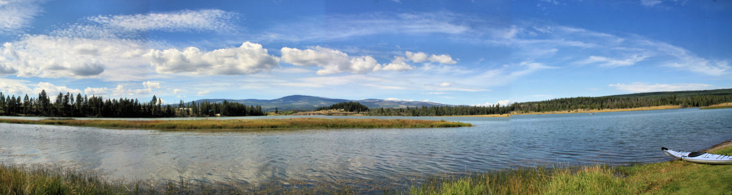
By the second week of April. many of the lower lakes become ice-free and have good vehicle access. On a calm and mild morning I drove to the west end of Paul Lake on the Harper Mountain Road. I hand launched into the lake and paddled up the north shore of the lake toward Gibraltar Rock.
I paddled about 3.1 km up the shoreline to an area near the beach boat launch and then turned around and paddled back on the same shore. On the south side of the lake, there are homes, docks, and noise, and the north side has trees, bluffs, and ducks.
Gibraltar Rock juts out into the lake, similar to paddling around Battle Bluff. When the wind is out of the west, the area from the bluff to the beach is usually calmer, lying in the lee of the winds.
There were winds for the middle part of the 6.2 km paddle, but the winds died coming back to the start.
This was the first day of paddling on Paul Lake. I usually paddle about three times, but I also paddle nearby Louis Lake and later on to Pinantan Lake and Hyas Lake. This was the 11th day of paddling in 2024. I try to paddle Mondays and Fridays and sometimes other days, but conditions (wind and smoke) dictate which days are paddle days and which days are for hiking.
Inks Lake is a smaller lake with a muddy shoreline. In spring the water is clear and there are lots of ducks on the lake. It is rare to see anyone else on the lake.
There are 3 sections of the lake. From the main lake area, we can paddle through a narrow channel to find two more bays. When we paddle the lake in spring, we paddle all 3 bays and then usually do it again in the opposite direction. The lake was down about 2 feet so the west bay was shallow and choked with aquatic plants.
This paddle took about an hour in warm and calm conditions. there were ducks and geese on the lake and I spotted killdeer, robins, and crows. Meadowlarks were signing in the grasslands above. Now that the pipeline is finished, it is much quieter in the area.
It is a scenic spot in the spring, but less appealing in the summer.
Inks Lake is one more of many lakes to paddle each year.
In the first third of April, the benchland lakes are all ice free and can be paddled. Jacko Lake, Inks Lake, and Pat Lake have good access for a day of spring kayaking. On a sunny morning with little wind I arrived at Jacko Lake and joined the fly fishermen on the lake. The lake was about 2 feet down from previous years so some of the bays are shallow, but we can still stay close enough to the shoreline to stay out of the way and enjoy the views.
Jacko Lake is a favourite and I will probably paddle there several times this year. It takes about 50 – 55 minutes to paddle all the shoreline, including the bays and sometimes I go around once and other times twice. The weather was sunny and warm.
There were ducks and geese on the lake. Killdeer, meadowlarks, magpies, crows, and swallows were also spotted. the large eagle’s nest on the southeast shoreline seemed to be empty. Sandhill cranes flew overhead. The work on the pipeline was done so the area is now much quieter. A few images from the morning on the lake are shared here. All photos taken that day by the author. Click an image for a lightbox view.
On an early April morning the weather was mild but there was a 10 km wind from the south on Monte Lake. I launched and paddled into the wind, heading south down the lake. There were two other fishing boats on the lake, the highway was busy and a train came up the western shoreline, but the west shoreline was quieter for much of the paddle as I looped back in a clockwise direction for a 1.25 hour outing.
contI tried a different launch spot this time, parking and launching from a designated area on the eastern shore. This was a good launch, though the highway noise detracts from the spot.
The wind died back on the second half of the paddle as the sun started to break through the clouds. this was the 7th day of paddling for 2024. In most years I paddle once on Monte Lake, but this was the first time for an April paddle on this lake, below the black forests on the hillsides above.
On April Fools Day there was no wind forecast for morning in the Merritt area. Nicola Lake is about 60 km south on Highway 5A so an early start ensured a launch time in calm conditions. There are a few boat launches along Nicola Lake and the first one just off the highway has a picnic area and a gravel launch area. there was no one else on the lake as I paddled south along the shoreline. On this loop route I spotted ducks, geese, crows, and eagles. The lake was flat and it was quiet, except when a truck went by the lake. I paddled south then crossed the lake to come back on the other side.
There are a small number of summer homes on the northwestern shore, then a series of rocky bluffs. Near the end of the lake are farmlands.
A few images are shared here. Click an image for a lightbox view.
DCIM100GOPROGOPR0480.JPG
DCIM100GOPROGOPR0486.JPG
This was an 8.2 km paddle taking about 1.6 hours. Finding calm water on Nicola Lake is always a blessing and the fine spring weather made this an ideal outing. The goal is to paddle each lake at least once and the bigger lakes usually get more than one day of paddling, with subsequent days on a different part of the lake.
At the end of March, the valley bottom lakes were ice-free. Some of them are larger lakes so we have to pick a mild day with little wind. The chain of lakes (Trapp, Shumway, Napier, Stump, and Nicola) on Highway 5A South are good choices at this time of year. Trapp Lake is a long narrow lake next to the highway, but there is good access for paddlers. The whole lake is a longer paddle, so I usually do the north or south end on one day, then the other at another time. This is an alkali lake with no fishing so it is rare to see another boat on the lake. In summer the algae multiplies so spring is the best season to paddle the lake.
I paddled up the west side of the lake and followed the shoreline in a clockwise loop, a 6.1 km kayaking day.
Grasslands hills rise steeply on the west side of the lake. Wind-streaked (lenticular) clouds painted the skies above.
On the way back down the east side of the lake, the sun shone through the clouds and the wind died down.
The east side of the lake is mostly steep wooded slopes. Trees by the shoreline sometimes tilt over the lake’s waters.
In a few sheltered bays on the east side, ice shelves persisted.
In this phase the upland lakes are still ice-bound, but paddling on the lakes will be a bi-weekly schedule with the Highway 5A lakes, but also lakes in the Thompson River Valley (Little Shuswap, White Lake, Shuswap Lake, Kamloops Lake, and some benchland lakes too).
On a mild and calm day on the second day of spring, I drove down the bumpy road to Cooney Bay, then hauled my kayak down to the shoreline of the estuary. I launched in a shallow channel and worked my way out to Kamloops Lake. There were swans, geese, ducks, and gulls in the channels and on the lake. With no wind and the sun breaking through clouds, it was a perfect day for a paddle. I padded around Cooney Bay then continued along the bluffs going west.
The goal for the day was to paddle around the base of Battle Bluff, then turn around and paddle back the same way.
Kamloops Lake is often a windy area so when the forecast is for no wind, Kamloops Lake, Nicola Lake, Little Shuswap Lake. or Stump Lake are on the list for a longer paddle. This one was about 1.5 hours. the next time I paddle the lake, it will be from the west end. Some images from the paddle are shared here. click an image for a lightbox view.
The first few days of paddling each year are spent on the river, launching from Pioneer Park, Riverside Park, or Valleyview. Once the weather warms and the winds abate, the valley-bottom lakes are next. On a calm March morning the winds were light and the sun was out on the South Thompson River.
There were ducks and geese on the river. On the shore were crows, magpies, and an occasional dog walker. A swan flew overhead, heading upstream. I paddled up past the Yellowhead Highway Bridge and turned around, happy with a one hour paddle on the river.
In mid-March the weather was perfect for an early paddle on the rivers. From Pioneer Park, the route was downstream, under the Red Bridge, then under the Train Bridge toward the Confluence of the South Thompson and the North Thompson Rivers.
There are a number of sand and gravel bars at the Confluence so it is best to stick to the south shore, passing under a third bridge (Overlander Bridge) and beyond down the Thompson River to the old bridge pylons from the old (1925 to 1961) Black Bridge.
Beyond the pylons, we can still see the footings of the older-yet White Bridge (1901-1925). At low water, these are rocky high spots in the river. Paddling around these, I returned back upstream, paddling toward the morning sun.
There is a bit of turbulent water at the Confluence. Progress upstream is slow.
Paddling down toward Rabbit Island and back is about 6 km. This is a better paddle in the early or late season when there are no powerboats on the river. Paddling on a day without strong winds is always a good practice.
We usually paddle the rivers for a while before ice is off the lakes. We can launch from Pioneer Park, Riverside Park, Valleyview Boat Launch, and from some hand launch sites in Westsyde. The ice comes off Kamloops Lake first, along with Little Shuswap Lake. Since these are bigger lakes, we wait for a calm, mild day.
Not long afterward, there are more lakes to paddle. Nicola and Stump Lake are good for a day without strong winds. Trapp Lake is often one of the first ice-free lakes. White Lake is open about the same time. In mid-April we can usually paddle Jacko Lake, Inks Lake, Pat Lake, and Morgan Lake. The fisherman also are keen on starting their year on Jacko, Pat, and Morgan so we look for non-prime times. Paul Lake and Louis Lake open up, as well as others, but the gates sometimes remain closed so access may wait for a later date.
A probable itinerary will be:
March – South Thompson, Thompson, and North Thompson River.
Early April – Kamloops Lake, Trapp Lake, Nicola Lake, Little Shuswap Lake, White Lake, and Stump Lake.
Later in April – Pat and Morgan, Jacko, Louis Lake, and Paul Lake.
May – August – the rest of the area lakes.
We will paddle when we can in March, then 2-3 times a week from April through to early November, dodging unfavorable conditions (those become a day to hike instead. See you on the water!
During September a few years ago, we traveled to Murtle Lake before smoky conditions in smothered the area and we decided to shorten our time there once the smoke moved in. On the second day we paddled the west end of the west arm of Murtle Lake. We launched from Birch Beach and paddled past Smoker Island. The wide bay at the mouth of File Creek and Anderson Creek is shallow and muddy so we kept our distance from the treed shoreline. The distance from Birch Beach to the landing at Diamond Lagoon was about 7.5 km.
At the end of the previous day and in the early morning, there was some smoke, but there was also some clearer skies too. We got an early start to take advantage of calm conditions on the lake.
The mountains to the north of Anderson Lake and Anderson Creek are part of the Mobley Range. There is a trail to Anderson Lake, but access to Mobley Mountain would be bushwhacking.
There is also a trail to a launch at File Creek. the river can be paddled for about 4 km upstream. McDougall Lake is another 5 km beyond. Draining into File Creek is Kostal Creek, running down from Kostal Lake (6km from the confluence). An old trail can be hiked to Kostal Lake, but it is mostly impassable at this time. The Goat Peaks rise north of File Creek.
We entered Diamond Lagoon by paddling a short distance down the Murtle River. The lagoon area is through a lava field. At the end of Diamond Lagoon are rapids on the river. A sign warns paddlers not to pass the sign.
A rough landing can be made on the south shore. A trail follows the river down to McDougall Falls.
We landed in a small bay below the Diamond Lagoon shelter. We had lunch and explored the area a bit. The shelter would be welcome in the rain or the cold, but it is a bit primitive otherwise. There was an outhouse and a bear cache there for campers.
The smoke continued to roll in as we paddled back along the south shore of the lake.
We paddled past the Tropicana Campsite and then across the lake to our own campsite, a total of 16 km.
On a day with better conditions, we would have hiked down to the falls and back, but paddling in the smoke limits the views, but it also takes a toll on the lungs. We spent 3 day at Murtle Lake, but we plan to return to do some more hiking in the area, perhaps in the North Arm next time.
Note – this was posted on KamloopsTrails.net but as I wind down that site, I am transfering kayaking posts to this site.
The first days of kayaking each year are done in cool weather and the water temperature is cold, dangerously cold if you capsize. When I go out, I take the following precautions.
I wear a full dry suit. These are expensive so not everyone has one. I look at it as a one-time investment. If I go in the water, the dry suit will prevent me from cold shock as long as I am close enough to the shore or I can perform a self-rescue.
I have practiced self-rescue many times so I can be back in the boat in a couple of minutes. I carry a baler/pump, a sling for the self-assist, and I would then make my way to the shore ASAP.
I wear full neoprene boots to further insulate myself. This allows me to get into the boat or out of the boat by stepping in the water.
I paddle along the shoreline every time in the early season. I do not cross large lakes.
While paddling I wear paddling gloves and a toque or adjustable toque hat.
I wear breathable layers under my dry suit.
I always wear a PFD and I have the required safety equipment.
I do not paddle on windy days in the early season. I use the limit of 15 km/hour. Reasonably reliable forecasts can be seen on Environment Canada sites 24 hours in advance.
I keep the distance to 45 – 90 minutes in cool weather.
I pick reliable spots on the river or local lakes in the early season, preferably spots where I can be seen if something goes wrong.
I let someone know where I will be and I check in by text.
I haven’t tipped in by accident for 20 years, but I still take all the precautions every time.
When the water warms up, I can ease up on some of the extra safety precautions.
I was paddling on Paul Lake at the first ice off and there was a family with a Costco kayak there, taking turns. No PFDs and paddling out to the middle of the lake… I told the parents that if someone tips, that person would not survive and anyone on the shoreline would not be able to rescue them. I was given a cold glare and no response.
In the last week of February the days were mild and the snows melted. The river was clear of ice. The gate to the boat launch at Pioneer Park is still locked (??) so it is a bit awkward getting the boat down to the water. I launched into the water and paddled upstream. Without much wind, it was a pleasant paddle for about an hour.
The last day of paddling in 2023 was a cold day on November 12th, 98 days ago. We will be out paddling lots more over the next 9 months. A short video shares some of these moments:

 I kayaked around the south side of the island and then landed on the east side landing area.
 I secured the boat and the gear, put on a pair of hiking shoes and then hiked the 2.6 km Copper Island Trail.
 The double loop route was 7.25 km. This is a very nice outing on a calm day in spring. I don’t recommend starting in the afternoon on a busy summer day.
 More Information:


 There were ducks and geese on the lake. Killdeer, meadowlarks, magpies, crows, and swallows were also spotted. the large eagle’s nest on the southeast shoreline seemed to be empty. Sandhill cranes flew overhead. The work on the pipeline was done so the area is now much quieter. A few images from the morning on the lake are shared here. All photos taken that day by the author. Click an image for a lightbox view.


 T
T