On a calm day with mild temperatures I drove out to Scotch Creek Provincial Park paddled from the boat launch area over to Copper Island
I kayaked around the south side of the island and then landed on the east side landing area.
I secured the boat and the gear, put on a pair of hiking shoes and then hiked the 2.6 km Copper Island Trail.
The double loop route was 7.25 km. This is a very nice outing on a calm day in spring. I don’t recommend starting in the afternoon on a busy summer day.
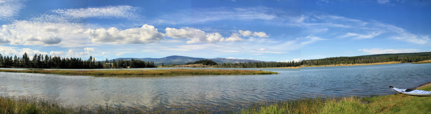
By the second week of April. many of the lower lakes become ice-free and have good vehicle access. On a calm and mild morning I drove to the west end of Paul Lake on the Harper Mountain Road. I hand launched into the lake and paddled up the north shore of the lake toward Gibraltar Rock.
I paddled about 3.1 km up the shoreline to an area near the beach boat launch and then turned around and paddled back on the same shore. On the south side of the lake, there are homes, docks, and noise, and the north side has trees, bluffs, and ducks.
Gibraltar Rock juts out into the lake, similar to paddling around Battle Bluff. When the wind is out of the west, the area from the bluff to the beach is usually calmer, lying in the lee of the winds.
There were winds for the middle part of the 6.2 km paddle, but the winds died coming back to the start.
This was the first day of paddling on Paul Lake. I usually paddle about three times, but I also paddle nearby Louis Lake and later on to Pinantan Lake and Hyas Lake. This was the 11th day of paddling in 2024. I try to paddle Mondays and Fridays and sometimes other days, but conditions (wind and smoke) dictate which days are paddle days and which days are for hiking.
On an early April morning the weather was mild but there was a 10 km wind from the south on Monte Lake. I launched and paddled into the wind, heading south down the lake. There were two other fishing boats on the lake, the highway was busy and a train came up the western shoreline, but the west shoreline was quieter for much of the paddle as I looped back in a clockwise direction for a 1.25 hour outing.
contI tried a different launch spot this time, parking and launching from a designated area on the eastern shore. This was a good launch, though the highway noise detracts from the spot.
The wind died back on the second half of the paddle as the sun started to break through the clouds. this was the 7th day of paddling for 2024. In most years I paddle once on Monte Lake, but this was the first time for an April paddle on this lake, below the black forests on the hillsides above.
On April Fools Day there was no wind forecast for morning in the Merritt area. Nicola Lake is about 60 km south on Highway 5A so an early start ensured a launch time in calm conditions. There are a few boat launches along Nicola Lake and the first one just off the highway has a picnic area and a gravel launch area. there was no one else on the lake as I paddled south along the shoreline. On this loop route I spotted ducks, geese, crows, and eagles. The lake was flat and it was quiet, except when a truck went by the lake. I paddled south then crossed the lake to come back on the other side.
There are a small number of summer homes on the northwestern shore, then a series of rocky bluffs. Near the end of the lake are farmlands.
A few images are shared here. Click an image for a lightbox view.
DCIM100GOPROGOPR0480.JPG
DCIM100GOPROGOPR0486.JPG
This was an 8.2 km paddle taking about 1.6 hours. Finding calm water on Nicola Lake is always a blessing and the fine spring weather made this an ideal outing. The goal is to paddle each lake at least once and the bigger lakes usually get more than one day of paddling, with subsequent days on a different part of the lake.
At the end of March, the valley bottom lakes were ice-free. Some of them are larger lakes so we have to pick a mild day with little wind. The chain of lakes (Trapp, Shumway, Napier, Stump, and Nicola) on Highway 5A South are good choices at this time of year. Trapp Lake is a long narrow lake next to the highway, but there is good access for paddlers. The whole lake is a longer paddle, so I usually do the north or south end on one day, then the other at another time. This is an alkali lake with no fishing so it is rare to see another boat on the lake. In summer the algae multiplies so spring is the best season to paddle the lake.
I paddled up the west side of the lake and followed the shoreline in a clockwise loop, a 6.1 km kayaking day.
Grasslands hills rise steeply on the west side of the lake. Wind-streaked (lenticular) clouds painted the skies above.
On the way back down the east side of the lake, the sun shone through the clouds and the wind died down.
The east side of the lake is mostly steep wooded slopes. Trees by the shoreline sometimes tilt over the lake’s waters.
In a few sheltered bays on the east side, ice shelves persisted.
In this phase the upland lakes are still ice-bound, but paddling on the lakes will be a bi-weekly schedule with the Highway 5A lakes, but also lakes in the Thompson River Valley (Little Shuswap, White Lake, Shuswap Lake, Kamloops Lake, and some benchland lakes too).
On a mild and calm day on the second day of spring, I drove down the bumpy road to Cooney Bay, then hauled my kayak down to the shoreline of the estuary. I launched in a shallow channel and worked my way out to Kamloops Lake. There were swans, geese, ducks, and gulls in the channels and on the lake. With no wind and the sun breaking through clouds, it was a perfect day for a paddle. I padded around Cooney Bay then continued along the bluffs going west.
The goal for the day was to paddle around the base of Battle Bluff, then turn around and paddle back the same way.
Kamloops Lake is often a windy area so when the forecast is for no wind, Kamloops Lake, Nicola Lake, Little Shuswap Lake. or Stump Lake are on the list for a longer paddle. This one was about 1.5 hours. the next time I paddle the lake, it will be from the west end. Some images from the paddle are shared here. click an image for a lightbox view.
Every year I try to paddle some new lakes, even if they are difficult to access. Two of the lakes paddled this last year included Pemberton Lake and John Frank Lake.
There are a few small lakes high on the shoulders of the ridges between Mt. Lolo and Shaw Hill. We paddle Hyas Lake every year and it is one of our favorites. Off side roads are other smaller lakes like Andy Lake, Pemberton Lake, and Warren Lake. After paddling Hyas Lake, I packed my folding kayak on a backpack and hiked for 0.7 km into marshy Pemberton Lake. I paddled around the lake twice (2.4 km), then hiked back out. There is a small Rec Site at the lake, but the road is rough and there were fallen trees. It is a pleasant spot, with marshy shoreline, but it is very quiet and seldom visited.
John Frank Lake is in Roche Lake Provincial Park. It is accessed by a rough 2.5 km road. There is a hand launch spot on the lake. The lake has lots of marshy areas and some of the bays become grown-in with aquatic vegetation in summer. A paddle around the shoreline is 2.8 km so two loops may be a good option. It is a scenic spot and it would be a regular spot to paddle except for the rough road. Nearby is Frisken Lake which I have hiked into, but haven’t yet paddled. The rough road to the lake is about 1.3 km so it may be pack-and-paddle route in 2024.
More lesser-known lakes will be featured over the winter…
Each year I try to paddle on some new lakes. In this last year I paddled a few of them, including Black Lake and Fred Lake.
Black Lake is located in Roche Lake Provincial Park. It is a destination lake for fishing, but the road in is very rough. I have driven it, but regretted it and vowed never to do it again. I have hiked the road a few times, usually on a loop route hike past a series of lakes. I hiked in with a folding kayak in a backpack and paddled around the lake twice (4 km). There were fishermen who had driven in. I talked to one of them who was camped there. He said he just drives very slowly in and out. It is a very nice lake and one I will return to paddle.
Fred Lake lies in a forested area east of Lac le Jeune. We can drive backroads (Ross Moore FSR), but the last access track is too narrow, overgrown, and rough for most vehicles. I packed in my folding kayak and paddled twice around the lake (3.5 km). It is surrounded by forest, but it may be a burned area now with lots of fallen trees. It lies only 0.7 km from Ross Moore Lake. Because of this, it may be a once-only lake.
Every year I try to find some new lakes in the area to paddle. Access to some of the lakes may be an issue. Rough roads and launch spots are a deterrent and the effort has to be weighed with the benefit. After doing some of the lakes, I may decide that it was a once-only effort. Other spots call for another visit.
Two of the lakes from this year were Buse Lake and Chuwhels Lake.
Buse Lake has relatively easy access, just off Barnhartvale Road, but I had to haul the kayak down the slope and launch in a muddy area. It is an alkali lake and late in summer the oxygen in the lake depletes and so we can observe brine flies and brine shrimp. Alkali salts ring the lake and a red band of pickleweed grows above the white ring. It is a quiet place for a paddle. The cliffs of Buse Hill rise above the lake to the south. The lake and the hill are part of BC Parks (Protected Area). A paddle around the lake is about 2.2 km so two loops is a good option. When I paddled the lake in the summer, there were still lots of ducks on the lake. It can be combined with a hike around the lakeshore, enjoying the salt marsh ecosystem.
Chuwhels Lake lies in a small remote valley between Chuwhels Mountain and Greenstone Mountain. Access is by bumpy backroads. We can get to the lakeshore with a high clearance vehicle in dry conditions from the Greenstone Mountain Road, then a series of side roads. The lake is dammed and we can hand launch from the shoreline. The shoreline is forested with some rock bluffs above the shoreline on the south side. It is a quiet spot that has some fish in the lake. A paddle around the shoreline is about 1.4 km, so two loops plus the hike in carrying the kayak is about right. I sometimes combine this with a hike on the Greenstone Mountain Trails or the Upper Cherry Creek backroads.
More lesser-known lakes will be featured in upcoming posts…
When the weather is marginal I got out to one of 4 lakes – Jacko, Edith, Paul, or Edith Lake. On a day that was forecast for wind and rain, I got an early start.
On the open part of the lake, it was a bit windy and cool, but I did a counter-clockwise loop and entered the back channels, more protected from the wind.
There are two out-and-back bays on that end of the lake, both protected from the wind, but also hidden, with no other boats in sight.
The end of the back channel is surrounded by grazing lands. I usually round the deadhead and return by the other shore.
A circuit around the lake takes about 50 minutes so I go around twice, once in each direction on some days. On this day it was under an hour of paddling, a shorter outing for a busy day.
I will be back to paddle the lake again, then in winter to snowshoe around the lake.
Near the end of the paddling season, the bays were freezing over and snow and frost covered the vegetation on the shoreline. I wore ski gloves to paddle and kept the outing under an hour.
Winds were cold. The end of the season had arrived. I broke ice on one of the bays:
At this point the first day of kayaking in 2023 was March 13 and the last day was November 12th. Three months to the first spring paddle in 2024…
At the end of October the air was cold and ice had formed in the shallow bays of Jacko Lake.
There was no wind so I ventured out to paddle around the lake. Frost covered the north-facing hills and some of the icy bays couldn’t be paddled, but there were swans and ducks on the lake, a muskrat swimming across, and an eagle watching over the lakeshore. A couple of bundled-up fishermen were out, casting their lines.
With work on the Trans Mountain Pipeline close by, it was not quiet, but the lake was peaceful. Staying warm takes work so steady paddling for an hour was the course of action. I was hoping for a couple of additional days of paddling before winter sets in.
It’s a lake that seems to have poor water quality for much of the year, the highway is along one side of the lake, and there are ranches/farms on either end. There have been water quality advisories from an algae bloom in the past and to my mind, the lake has a greenish hue all year round. The lake is fed by Guichon Creek, Meadow Creek, and Chartrand Creek, all of which go through farm lands, ranching properties, and marshy lakes. The lake is a reservoir with a dam at the south end, used to provide water to ranches downstream.
In the fall the algae bloom was mostly over, but the algae was still everywhere in the water, a less-than-appealing paddling experience.
I paddled for an hour completing a loop on the lake.
Its not that Mamit Lake is a bad spot, but there are 50 better lakes to paddle in our area. I won’t be back again.
Fall conditions continued to set in and cooler weather limits which days and which locations I paddled. On a cool morning (5 C) with a light wind, there was only one other boat on Edith Lake.
Smaller lakes are a better choice in windy or colder conditions and I can choose one, two, or three loops.
If I paddle all the bays, I can paddle the lake in 45 – 55 minutes. With cool conditions I paddled non-stop and loaded the boat quickly. I am not sure how many more days I will have in 2023 since minus degree temperatures are forecast.
Watch the Ramble On Channel Video Podcast on Cool Weather Paddling now available.
As the fall weather provides cooler conditions we often return to home base – the river, Edith Lake, Stake Lake, and Jacko Lake. Most lakes are paddled once or twice in a year, but Jacko is a favorite so I paddle there 6- 8 times each year. On a grey fall day, I launched my kayak and paddled around the lake.
There was a lot of construction going on on the newly-rerouted Trans Mountain Pipeline just to the north of the lake, but otherwise there were some fishermen, some ducks and eagles, and one kayak on the lake. The lake is a scenic spot in every season, but there was some fall colour too. The surrounding grasslands had very little rainfall so the hills were a shade of amber.
In the summer, the shallow bays become choked with aquatic growth, but there is more open water once the water temperatures cool down.
Eagles were doing swoops over the lake and coots were diving, but they worked in pairs taking turns to eventually catch their prey. I watched the same thing happen at Mamit Lake the next day.
The final days of paddling will mostly be on nearby lakes and on the South Thompson River. The paddling year will have started mid March and will end some time in November.

 I kayaked around the south side of the island and then landed on the east side landing area.
 I secured the boat and the gear, put on a pair of hiking shoes and then hiked the 2.6 km Copper Island Trail.
 The double loop route was 7.25 km. This is a very nice outing on a calm day in spring. I don’t recommend starting in the afternoon on a busy summer day.
 More Information:


